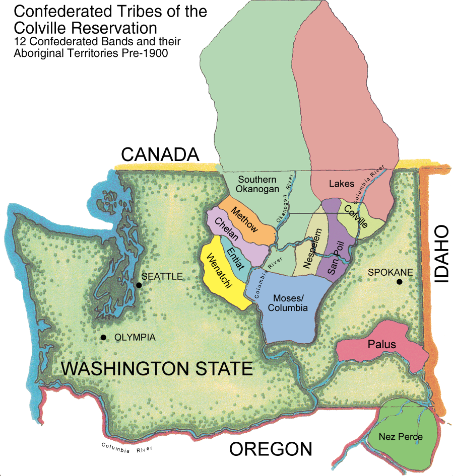
Twelve Bands

Twelve Bands compose the Confederated Tribes of the Colville Reservation:
Chelan, Chief Joseph Band of Nez Perce, Colville, Eniat, Lakes Methow, Moses-Columbia, Nespelem, Okanogan, Palus, San Poil, Wenatchi
Total Size: 1.4 Million Acres (2,100 Square Miles)
Tribal Enrollment Total: 9,500 (as of 2015)
Reservation Physical Characteristics:
The Reservation, located in north central Washington, lies in a physiographic province called the Okanogan Highlands. The reservation is located in the southeastern section of Okanogan County and the southern half of Ferry County, but there are pieces of trust land located in Chelan County. A period of compression and uplifting formed the present mountains; however, glacial erosion shaped much of the land to its present form.
Elevation of the Reservation lands generally increases from South to North and from West to East.
Elevations range from 790 feet at the mouth of the Okanogan River to 6,774 feet at the Summit of Moses Mountain. Average elevation of the Reservation is above 3,000 feet.
Summers, on the plains, are sunny, warm and dry with some hot days. During 4 or 5 months, in the lower elevations extreme highs may be 100°F, while, in the higher elevations 1 or 2 months may reach above 90°F. In winter, minimum temperatures of -10° to -20°F are common although a few stations report -25° to -30°F. Normally, precipitation is light in the summer and heaviest in the winter. Valleys and lowlands receive an average of 10 to 14 inches of precipitation; in the mountains, precipitation increases with elevation where 25 to 30 inches per year can be expected on the higher ridges, with the majority occurring as snow. Growing seasons vary from over 180 days in the Southwest to less than 80 days in the forested highlands.
The most abundant soil parent materials found on the Reservation are produced by glaciation, water laid glacial out wash or alluvium and lacustrine sediments are the only materials of major agricultural importance. Most of the soils that are suitable for cultivation occur on the level to undulating alluvial and out wash terraces and in isolated upland areas.
The major vegetative cover is divided into two groups: forest and steppe. Forest areas range from open forested grasslands to dense coniferous forests. Dominant species in forested areas are Ponderosa Pine, Douglas Fir, Lodge Pole Pine, and Western Larch. A number of sub shrubs and roots are as important to Tribal gatherings today as they were in years past.
